Guided Climb to Almaty Peak (4,376 m) – The Highest Summit on Almaty’s Skyline
From $199 per person
Overview
Is this hike right for you?
Perfect if you…
Be prepared
Description
A guided 2-day mountaineering ascent of Almaty Peak (4,376 m) — formerly Komsomol Peak, formerly Nursultan Peak — via the standard route from Talgar Pass through the Bogdanovich Glacier, Komsomol Pass (4,040 m), and the via ferrata ridge to the summit. The highest point visible from Almaty city. Category 2A-2B. Cable car access to 3,200 m. Overnight camp at Nunatak (3,600 m) on the glacier.
What to expect on the Almaty Peak climb
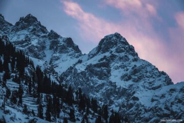
Look south from almost anywhere in Almaty on a clear day and you’ll see it: a sharp rocky pyramid rising above the ridgeline, higher than everything around it. That’s Almaty Peak, 4,376 metres above sea level — the highest point on the city’s skyline and the most climbed technical summit in the Zailiyskiy Alatau. The Almaty Peak climb is the definitive mountaineering experience in the Almaty region: a route that combines glacier travel across the Bogdanovich Glacier with a via ferrata-style rock section to reach a summit visible from 1.2 million people’s windows.
This is not a hike. Above Komsomol Pass (4,040 m), the route requires ropes, belaying, and the ability to climb steel rungs bolted into rock while wearing crampons. But it’s also not an expedition. The cable car at Shymbulak delivers you to 3,200 m before you take a single step. The glacier approach is low-angle and straightforward. The technical climbing section — approximately 100 metres of elevation gain on metal rungs and rock — is more via ferrata than alpine face. For anyone with reasonable fitness, basic mountaineering awareness, and a competent guide, the summit is achievable.
The peak has had four names in under a century — a compressed history of Kazakhstan’s political transformations from tsarist geography through Soviet ideology, post-Soviet personality cult, and modern national identity. Standing on top, reading the summit plaque that now says “Almaty Peak” in Latin and Cyrillic, you’re standing on a mountain whose name has been rewritten more times than most countries change their flags.
Detailed itinerary
Day 1: Almaty → Medeo → Talgar Pass → Nunatak Camp (3,600 m)
Morning: Almaty → Medeo → Shymbulak → Talgar Pass (3,200 m)
Pickup from your hotel at 7:00 AM. Drive to Medeo — the world’s highest outdoor ice skating rink at 1,691 m. From Medeo, take the cable car system through Shymbulak ski resort to the upper station at Talgar Pass (3,200 m). The 20-minute cable car ride provides an aerial preview of the terrain: the peaks of Chkalov (3,892 m) and Fizkulturnik (4,068 m) with the hanging glaciers Ayak and Til on their northern faces, and — dominating the view to the south — the pyramid of Almaty Peak itself.
At Talgar Pass, you step off the cable car and into the alpine zone. Sparse vegetation: low grasses, cushion plants, then nothing but rock, moraine, and sky. Your guide distributes group equipment and conducts a briefing.
Talgar Pass to Nunatak Camp — 6–7 km, +400 m, 2.5–3 hours
The trail heads south along the left side of the valley on a rough ground track. After approximately 1 km, the route transitions to the left lateral moraine of the Bogdanovich Glacier. The path here is faint — marked intermittently by stone cairns and, in places, the informal waymarkers of Central Asian mountains (plastic bottles on posts). This is not a marked hiking trail. Navigation requires attention.
After about an hour of moraine walking, the path crosses to the middle of the valley around a large rocky ledge, then continues along the right side toward the glacier tongue. You’re walking beneath the northern walls of Chkalov Peak and Fizkulturnik Peak. Above you, the glaciers Ayak and Til hang from the cliffs — thick rivers of ice draped across vertical rock. Occasional distant sounds of ice and rockfall remind you that this is active glacial terrain.
The Bogdanovich Glacier tongue appears at approximately 3,374 m — a grey-white mass of ice, debris, and moraine. This is where the Bogdanovich Glacier day hike turns back. You continue.
Nunatak Camp (3,600 m)
Another 20–30 minutes beyond the glacier tongue brings you to Nunatak — a rocky outcrop (a true nunatak: an island of rock protruding through glacial ice) rising from the moraine in the middle of the glacier system. The flat areas beneath it provide the standard campsite for all glacier expeditions. Your guide sets up tents, prepares a hot dinner, and briefs you on tomorrow’s summit route.
The evening briefing covers: glacier travel protocol, crampon fitting, rope team procedures, the via ferrata section, turnaround time, and weather assessment.
Evening at Nunatak is extraordinary. You’re camped in the heart of a glacier system surrounded by 4,000 m+ peaks on three sides. To the south, the north face of Almaty Peak turns from grey to gold to deep orange as the sun sets. The silence — when the ice isn’t creaking — is absolute.
Day 2: Nunatak → Komsomol Pass → Summit (4,376 m) → Return to Almaty
Pre-dawn start: 4:00–5:00 AM
Wake in darkness. Cold breakfast, headlamps on, crampons fitted. The early start serves two purposes: firm glacier conditions (refrozen overnight) and sufficient time for the technical sections.
Nunatak to Komsomol Pass (4,040 m) — 2–3 km, +440 m, 1.5–2 hours
The route ascends the Bogdanovich Glacier, which above Nunatak is low-angle but crevassed in sections. Your guide selects the safest line — the crevasse pattern shifts year to year as the glacier evolves. In mid-summer, the ice is typically bare (no snow cover), making crevasses visible. On either side of the glacier, keep distance from the steep flanks — avalanche debris is commonly visible.
The glacier narrows as it approaches the saddle between Almaty Peak (east) and Karlytau Peak (4,170 m, west). You arrive at Komsomol Pass at approximately 4,040 m. Here the glacier ends and the rock begins.
At the pass, crampons come off. Trekking poles get stashed — there’s a traditional pile of poles left by climbers at the base of the rock section. You rope up.
The view south from the pass is dramatic: a 1,200-metre plunge into the Left Talgar River valley — the same remote, roadless valley described in our Left Talgar Gorge article, seen here from directly above.
Komsomol Pass to Summit — ~336 m vertical, 1.5–2.5 hours
This is the technical section. From the pass, the route ascends a broad talus/scree slope to the base of the rocky ridge. Here you encounter the via ferrata section: steel rungs bolted into the rock face, ascending approximately 100 metres of vertical gain. The original safety cable is no longer intact, but fixed bolts remain — your guide clips the rope through these for protection.
The via ferrata section has metal rungs in places running in two parallel lines, with occasional broken or missing rungs. This is not a modern European via ferrata with continuous wire cable — it’s a Soviet-era mountaineering aid that has been maintained informally over decades. With a guide managing the rope, the climbing is straightforward: you’re essentially ascending a steep ladder with rock scrambling between sections.
Above the via ferrata, the terrain eases to lower-angle but loose rock. The final approach to the summit follows the ridge northward, with belayed scrambling over broken, weathered rock. Depending on season, a snow and ice arête (30–40 m) may guard the final metres before the summit — typically traversed on crampons or bypassed to the right.
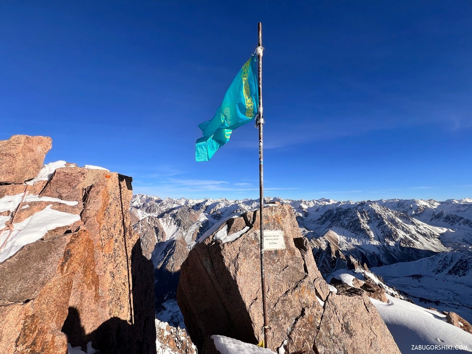
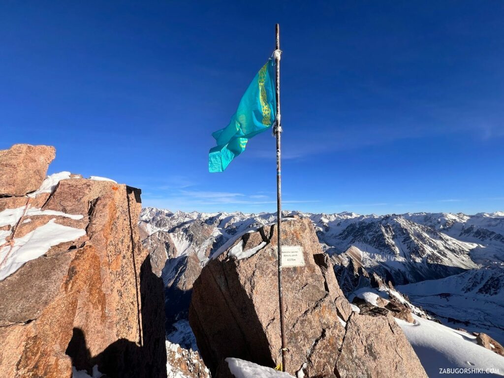
The Summit: 4,376 m
What you see from the top of Almaty Peak:
The summit carries a Kazakh flag and a metal plaque reading “Almaty Peak” in Latin and Cyrillic script.
North: The city of Almaty spreads across the plain roughly 3,600 metres below — apartment blocks, parks, and roads visible as geometric patterns. Beyond the city, the steppe extends to the horizon. On clear days, you can see over 100 km north.
East: The massive bulk of Talgar Peak (5,017 m) — the highest point in the entire Zailiyskiy Alatau and the only five-thousander in the Northern Tien Shan. In between: Aristov Peak (4,102 m), only 855 metres to the southeast.
South: The Left Talgar valley, 1,200 m below. An immense glaciated landscape stretching toward the main Zailiyskiy Alatau ridge.
West: Karlytau Peak (4,170 m) with its ice dome. Beyond it: Amangeldy Peak (4,010 m), Molodezhniy (4,147 m), and the chain of peaks guarding the western wall of the Small Almaty Gorge.
Northwest: Ordzhonikidze Peak (4,410 m) — actually the highest summit in the immediate neighbourhood at 4,410 m, though less prominent on the skyline.
Time at the summit: 20–40 minutes. Weather dictates — this is 4,376 m and conditions change fast.
Descent: Summit → Nunatak → Talgar Pass → Almaty (5–7 hours)
The descent retraces the ascent. The via ferrata section requires rappelling (your guide sets the anchors). Back at the pass, crampons go on for the glacier descent. At Nunatak: break camp, pack gear, hot tea. Then the familiar moraine trail back to Talgar Pass, cable car to Medeo, vehicle transfer to Almaty.
Total Day 2: 6–10 hours depending on group speed, conditions, and weather windows. Return to hotel by late afternoon or evening.
Why book a guided Almaty Peak climb?
This is a technical climb. Ropes, harnesses, belaying, and rappelling are used above Komsomol Pass. The via ferrata section has missing rungs and no intact safety cable. Solo attempts without rope systems are undertaken by experienced mountaineers (it happens), but for anyone without technical climbing autonomy, a guide is essential.
Glacier navigation. The Bogdanovich Glacier has crevasses. Your guide reads the current conditions and picks the safe line — a line that changes each season as the glacier retreats and its crevasse patterns shift.
Altitude management at 4,376 m. This is the highest summit in your catalogue. At this altitude, even fit people can experience nausea, headache, impaired coordination, and poor decision-making. Your guide controls pace, monitors symptoms, and makes the turnaround call if altitude sickness develops.
Rockfall. The rock above Komsomol Pass is weathered and loose. Helmets are mandatory. Groups climbing above and below you dislodge stones. A 2024 Wikiloc report describes rocks coming loose on the descent, requiring evasive action. Your guide manages group spacing and timing to minimise exposure.
Route-finding above the pass. The technical section has multiple line options and no marked path. In cloud, the summit ridge is disorienting. Experienced guides know the rock intimately.
A peak with four names
No mountain in Kazakhstan has been renamed as many times as this one. The naming history is a compressed political biography of the country.
Almaty Peak / Maly Almaty Peak (pre-1935)
The peak’s original name — “Little Almaty” or simply “Almaty” — followed the convention of naming peaks after the river valleys below them. The Malaya Almatinka (Little Almaty River) flows from the glaciers at the peak’s base through Small Almaty Gorge and into the city. The name was purely geographical.
In 1929, Grigory Beloglazov conducted the first reconnaissance toward the summit, reaching approximately 4,000 m via the Kogashik Pass approach to the Bogdanovich Glacier. The following year, in early July 1930, I.E. Mysovsky — secretary of the mining section of the Central Council of the Society for Proletarian Tourism — proposed an ascent. The team comprised Mysovsky, Beloglazov, V. Gorbunov, and A. Berggrin. On July 17, 1930, three of the four — Beloglazov, Mysovsky, and Gorbunov — reached the summit of what was then called Maloalmatinsky Peak. This was one of the earliest significant mountaineering achievements in the Northern Tien Shan.
Komsomol Peak (1935–1997)
On July 9, 1935, everything changed. The All-Union Leninist Young Communist League (Komsomol) organised the first mass Alpiniad — a politically charged mountaineering event in the spirit of Soviet collective achievement. A total of 249 people reached the summit in a single day. The campaign’s leader was V.M. Zimin (the same Zimin who later led the first ascent of Satpayev Peak in 1938). The commissar was Konstantin Komarov, secretary of the Alma-Ata city Komsomol committee.
Two days later, on July 11, 1935, the government formally renamed the peak “Komsomol” in recognition of the organisation’s role. Days after that, 14 Komsomol activists led by Kaisar Tashtitov, first secretary of the Komsomol regional committee, made their own summit ascent.
The name stuck for over sixty years. Soviet mountaineering guidebooks, topographic maps, and climbing classifications all used “Komsomol Peak.” The annual mass Alpiniad became a tradition — interrupted during the late Soviet and early independence periods, then revived in 1997.
Nursultan Peak (1997/1998–2023)
After Kazakhstan’s independence, the peak was renamed in honour of President Nursultan Nazarbayev — who had himself participated in a mass ascent of nearby Abai Peak (4,010 m) in 1995, guided by the legendary Anatoli Boukreev. The renaming reflected a broader pattern of post-Soviet place-naming honouring the new nation’s leadership.
For over two decades, “Nursultan Peak” appeared on maps, in guidebooks, and in the annual July Alpiniad regulations. It became the standard English-language name used by trekking operators and travel writers.
Almaty Peak (2023–present)
In July 2023, the Alpinism Federation of Almaty quietly listed the endpoint of the International Alpiniad “ALMATY-2023” as “Almaty Peak.” The renaming — back to an echo of the original pre-Soviet name — was not accompanied by a formal government announcement but was confirmed by the summit plaque, which now reads “Almaty Peak” in both Latin and Cyrillic script.
The peak has thus come full circle: from Almaty to Komsomol to Nursultan and back to Almaty. The pass below it, however, retains the Soviet-era name: Komsomol Pass.
For this article, we use “Almaty Peak” as the current official name, with “Komsomol Peak” included for SEO purposes — it remains the name most commonly used in English-language climbing databases, guidebooks, and search queries.
Acclimatisation strategy
Attempting a summit at 4,376 m without acclimatisation invites acute mountain sickness. We strongly recommend completing at least one — preferably two — high-altitude hikes before this climb.
Recommended progression:
- Mynzhylki Plateau — 3,000 m, difficulty 3/5. Minimum recommended pre-acclimatisation
- T-1 Glaciological Station — 3,440 m, difficulty 3.5/5. Tests your response to altitude near the Nunatak camp elevation
- Bogdanovich Glacier Day Hike — 3,500 m, difficulty 3/5. Same approach route as the summit climb. You’ll see exactly where Day 1 ends
- Komsomol Pass — 4,000 m, difficulty 4/5. Gets you to the base of the technical section without the summit commitment. The ideal “dress rehearsal”
- Kumbel Peak — 3,200 m, difficulty 4/5. Tests your fitness and endurance on sustained steep terrain
The ideal preparation: The Bogdanovich Glacier day hike 3–4 days before, followed by the Komsomol Pass overnight trip 1–2 days before the summit attempt. This gives you acclimatisation nights at 3,600 m and time at 4,000 m before committing to the full 4,376 m.
Frequently asked questions
How difficult is this compared to the other peak climbs in your catalogue?
This is the hardest product we offer — difficulty 5/5. The progression is: Satpayev Peak (4,317 m, category 1A, difficulty 4.5/5) uses a non-technical ridge route. Almaty Peak (4,376 m, category 2A-2B, difficulty 5/5) involves roped climbing on rock. The Satpayev climb tests your endurance and altitude tolerance. The Almaty Peak climb tests those plus your comfort on technical terrain with exposure.
Do I need prior climbing experience?
Basic mountaineering awareness is required — comfort with exposure (heights with significant drops below you), ability to follow rope commands, willingness to rappel. You do not need to be a trained rock climber. Your guide manages all technical systems. However, if you’ve never worn a harness, we recommend a half-day introductory climbing session before the trip.
What’s the via ferrata section like?
Metal rungs bolted into rock, ascending approximately 100 metres vertically. The rungs run in two parallel lines in places. Some rungs are broken or missing. The original safety cable is no longer intact — your guide uses the fixed bolts for rope protection instead. It’s comparable to climbing a steep industrial ladder, but on a mountain face at 4,100+ m with a drop below you.
What’s the difference between the 2A and 2B routes?
The standard route from Komsomol Pass via the north ridge (via ferrata) is graded 2A. The southwestern ridge variant, which ascends via rocky gendarmes (rock towers) with 5–8 m walls, is graded 2B. Most guided groups use the 2A route. The 2B is steeper and involves more complex rock navigation.
Can I do this in one day?
Technically possible for very fast, well-acclimatised climbers, but not offered as a guided product. The standard format — overnight at Nunatak (3,600 m) followed by a dawn summit push — provides crucial acclimatisation and avoids the dangerous scenario of being on the technical section in afternoon weather. The cable car starts at 3,200 m, which is already high — going from 3,200 m to 4,376 m and back in a single day without prior acclimatisation at camp altitude is a recipe for altitude sickness.
When was the first ski descent?
On May 8, 2015, Vitaly Komarov and Igor Podgursky completed the first ski descent of the southern couloir. In 2013, an American climber free-soloed the northwest face and skied down with skis carried on his back — believed to be the first ski descent via that route. Ski mountaineering on this peak is a niche but growing activity.
What’s the annual Alpiniad?
Every July, the Almaty Alpinism Federation organises a mass ascent of Almaty Peak — continuing a tradition that dates back to the 1935 Komsomol Alpiniad when 249 people summited in one day. The modern event draws hundreds of participants and is open to anyone in good physical condition, though the technical sections require rope teams. It’s the most popular competitive mountaineering event in Kazakhstan.
The Bogdanovich Glacier
The glacier that provides the approach to Almaty Peak was named in 1911 by the glaciologist Dmitriev, after the geologist and professor Karl Bogdanovich. It sits at the junction of the Maloalmatinsky and Komsomolsky mountain spurs, with its tongue at approximately 3,374 m.
Like virtually all glaciers in the Zailiyskiy Alatau, the Bogdanovich is retreating. Each year the moraine extends, the tongue recedes, and the crevasse patterns shift. Your guide’s local knowledge of current conditions is not a convenience — it’s a safety necessity.
The glacier system contains several passes beyond Komsomol: Panfilov Heroes (3,950 m), Uchitel (4,045 m), and Pioneer Pass (3,840 m, category 1B). In winter, the October Cave (Oktyabrskaya) — an ice cave within the glacier — is accessible and offered as a separate winter experience via the Tuyuksu Ice Grottos page.
Neighbouring peaks
The Almaty Peak summit provides a visual introduction to the major peaks of the Maloalmatinsky ridge system:
- Karlytau (4,170 m) — ice dome immediately west, separated by Komsomol Pass. Requires glacier climbing
- Aristov (4,102 m) — 855 m southeast. Pointed rock towers on the eastern ridge of Karlytau
- Amangeldy (4,010 m) — 2.1 km northwest. Named after Amangeldy Imanov, leader of the 1916 Central Asian revolt
- Chkalov (3,892 m) — 1.9 km northeast. Named after the Soviet test pilot Valery Chkalov
- Fizkulturnik (4,068 m) — on the eroded ridge north of Almaty Peak
- Ordzhonikidze (4,410 m) — 3.3 km northwest. Actually higher than Almaty Peak at 4,410 m, though less prominent on the skyline
- Pioneer (3,800+ m) — northeast, part of the same ridge system
Itinerary
Detailed itinerary will be provided upon booking. Our typical tour includes daily hikes through diverse terrains and cultural experiences.
Pricing
| Group Size | 1 person | 2 people | 3 people | 4 people | 5 people | 6 people Best value |
|---|---|---|---|---|---|---|
| Standard | $540 $540 total | $335 $670 total | $267 $801 total | $233 $932 total | $212 $1060 total | $199 $1194 total |
100% private tour — prices are per person based on group size. The more friends you bring, the less everyone pays!
What's Included
Included
Not Included
Our Guarantee
If weather forces a cancellation, you choose a free reschedule or a full refund. If you're not satisfied with your experience, we'll work with you to make it right. No questions, no hassle.
Private tours only (max 6) · Reschedule or full refund if weather cancels · No payment until confirmed
Traveler Stories
James & Lisa
Did the 2-day Altyn-Emel trip. The Singing Dune at sunset was magical. Our guide handled everything - permits, accommodation, meals. We just showed up and enjoyed. Already planning our next trip with Zabugorshiki.
Anna W.
Solo traveler here. I was nervous about hiking alone in a foreign country but the guide made me feel completely safe. The trail to Kok-Zhailau was beautiful and the photos he took of me were amazing. Only wish the hike was longer!
David R.
Third time booking with these guys. Butakovka, Big Almaty Lake, and now Titov Peak. Every single time the service is flawless. The fact that it's always private and max 6 people makes such a difference compared to other operators.
Share Your Experience
Tour At A Glance
Book This Tour
Weekend slots fill up fast — book early to get your preferred date
Pay securely after confirmation


Weather Forecast
overcast clouds
H: 5°C
L: 2°C
Mon, Jun 22
overcast clouds
3°C
-0° / 6°
Tue, Jun 23
clear sky
5°C
-0° / 9°
Wed, Jun 24
broken clouds
5°C
2° / 10°
Tour Location
Similar trails

Guided Climb of Peak 28 Heroes-Panfilovtsev (4,120 m)
From $159/personFrom $199
per person · weather refund
Complete Your Booking
Tour:
Date:
Participants
Add-ons
You're Almost There!
We'll contact you within 24 hours to confirm your spot and share everything you need to prepare for your adventure.
Request sent
We confirm your spot
within 24 hours
Summoning perfect weather
Hit the trail
On the channel
83 h
Drone flight hours
What we’ve filmed
59
Hikes filmed
704 km
Kilometers covered
44,439 m
Elevation gained
27
Countries visited
Plan your hike with us
A few quick questions and we will email you a tailored hike plan & quote.
When do you want to hike?
What's your experience?
How many of you?
Where do we send your plan?
Private guided hikes · no obligation.