
Overview
Is this hike right for you?
Perfect if you…
Good to know
Description
A demanding day hike from the Big Almaty Gorge through the Kaskabas gorge to the bare granite summit at 2,932 m — the “Bald Head” peak that divides the Prohodnoye and Kargalinskoye gorges, with views across four valleys to the peaks of the Northern Tien Shan.
What to expect on the Kaskabas Peak hike from Almaty
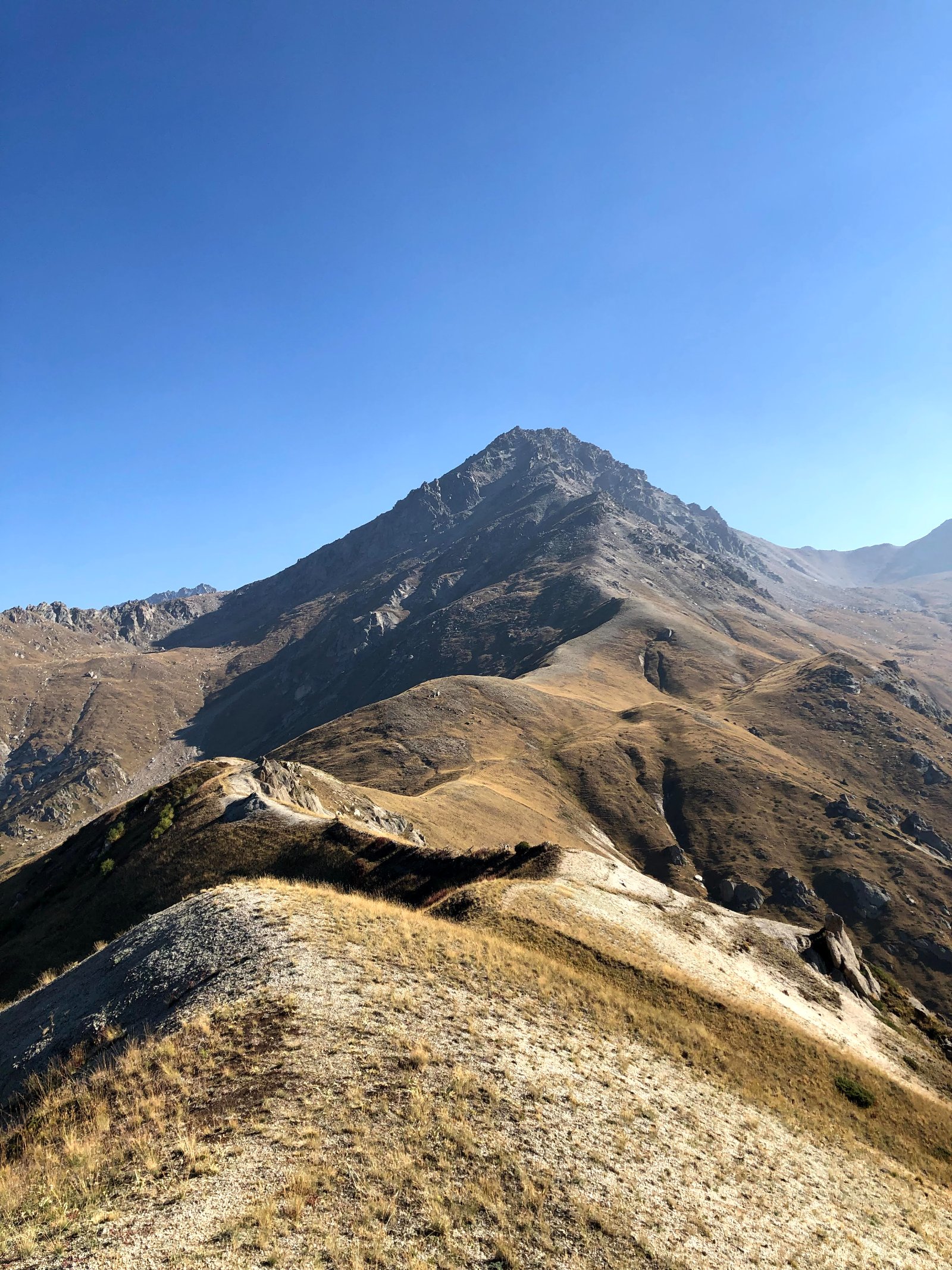
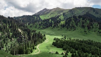
The Kaskabas Peak hike from Almaty is one of the most rewarding and least crowded summit climbs accessible as a day trip from the city. At 2,932 m, Kaskabas is high enough to put you above the treeline and onto a bare, grassy ridge with views in every direction — yet it requires no technical climbing, just fitness and determination. The name “Kaskabas” translates from Kazakh as “bald head,” which is exactly what the summit looks like: a treeless, rounded dome rising above the dark spruce forests of the surrounding gorges.
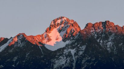
What makes Kaskabas special is its position. The peak sits at the junction of the Prohodnoye (Transit) gorge to the east and the Kargalinskoye gorge to the west, with the Kaskabas gorge running north from the peak toward the city. From the summit, you can see into all three gorges simultaneously, plus across to the Big Almaty gorge. The view south includes the pyramid of Big Almaty Peak (3,682 m) and the twin peaks of Kamenskiy (3,627 m) and Kargalinskiy — a perspective that few Almaty hikers ever see, because most stick to the more popular routes in the Small Almaty gorge.
The catch is the difficulty. This is a long, steep hike with a significant trailless section on a grassy slope approaching the pass. Your page rates it 4/5, and that’s fair. Well-prepared hikers complete it in 10–12 hours. The route is not technical, but it demands good fitness, early start, and adequate food and water.
Detailed Itinerary
Pickup and drive to the trailhead (30–40 minutes)
We pick you up early from your accommodation in Almaty — this hike requires a dawn start — and drive to the Big Almaty Gorge area. The trailhead is at the terminus of bus 28, near the 2nd Hydroelectric Power Station (GES-2) and the Ile-Alatau National Park ecopost. Elevation at the start: approximately 1,540 m.
The drive passes through the southern neighborhoods of Almaty, past the Sunkar Falcon Nursery — one of the world’s largest breeding centers for endangered saker falcons, established in 1989 — and into the entrance of the Big Almaty Gorge.
Through Prohodnoye Gorge to the Kaskabas turnoff (20–30 minutes)
From the bus 28 terminus, we walk about 1 km south along the Prohodnoye (Transit) Gorge road. Prohodnoye — meaning “passable” or “transit” — is one of the major gorges branching off the Big Almaty Gorge, historically used as a route between valleys. On the left (west) side, a dirt road turns into a smaller side gorge with a stream flowing from it. This is the Kaskabas gorge — our route.
A forestry house sits near the entrance. From here, the trail follows the stream.
Kaskabas Gorge: stream trail to the spring (1.5–2 hours)
The first 3 km of the trail are relatively straightforward — a well-defined path climbing gently along the Kaskabas stream, crossing from the western bank to the eastern bank as you ascend. The gorge is narrow, forested with spruce and birch, and quiet. You’re unlikely to see other hikers — x-travels.ru reports encountering nobody on this route and finding almost no signs of recent human presence, despite the trail being comparable in distance and accessibility to the popular Furmanov Peak hike.
After approximately 3 km, you reach a fork in the trail near a spring with a pipe (approximately 2,000 m elevation). This is a critical navigation point:
- Left (southwest): The direct route to Kaskabas Pass and the summit — steep, with minimal trail
- Right (north): The “Wolf’s Trail” toward Wolf Mountain (2,305 m) — a longer but better-marked alternative that can be used as a descent route
Fill water bottles at this spring. There is no reliable water above this point.
The steep ascent to Kaskabas Pass (1.5–2.5 hours)
This is the crux of the hike. From the spring, the trail turns southwest toward the Kaskabas Pass, visible as a saddle on the ridge above. The problem: there is essentially no trail. The slope is very steep — perhaps the most demanding sustained climb on any day hike near Almaty — and covered in tall grass that obscures footing. In wet conditions, this section becomes genuinely treacherous.
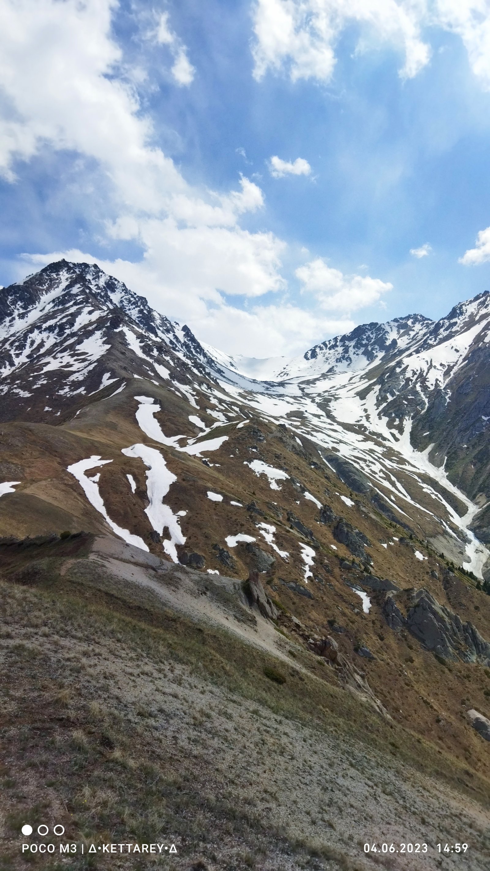
The pass sits at approximately 2,550–2,650 m elevation (sources vary: adrenalinicsilence.kz gives 2,650 m, x-travels.ru gives 2,550 m, Tengri Travel gives an unspecified saddle). The climb from the spring to the pass covers about 1.5 km horizontally but gains roughly 600 m vertically. Allow up to 2 hours for this section.
When you finally reach the pass, the effort is instantly rewarded: the entire Kargalinskoye gorge opens up to the west, a wide, beautiful valley that most Almaty hikers never see. To the south, the twin peaks of Kamenskiy (3,627 m) and Kargalinskiy are visible along the continuing ridge.
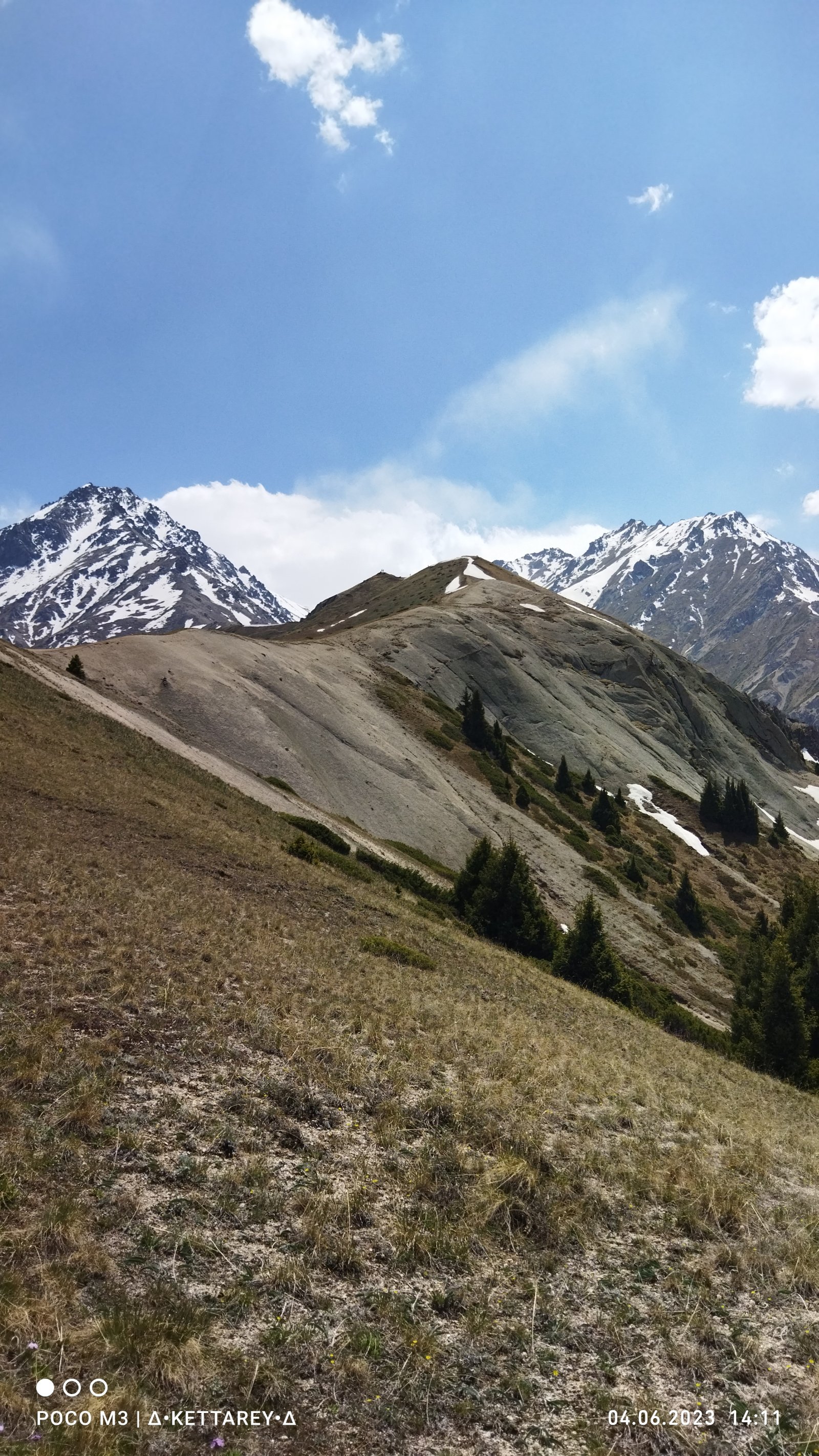
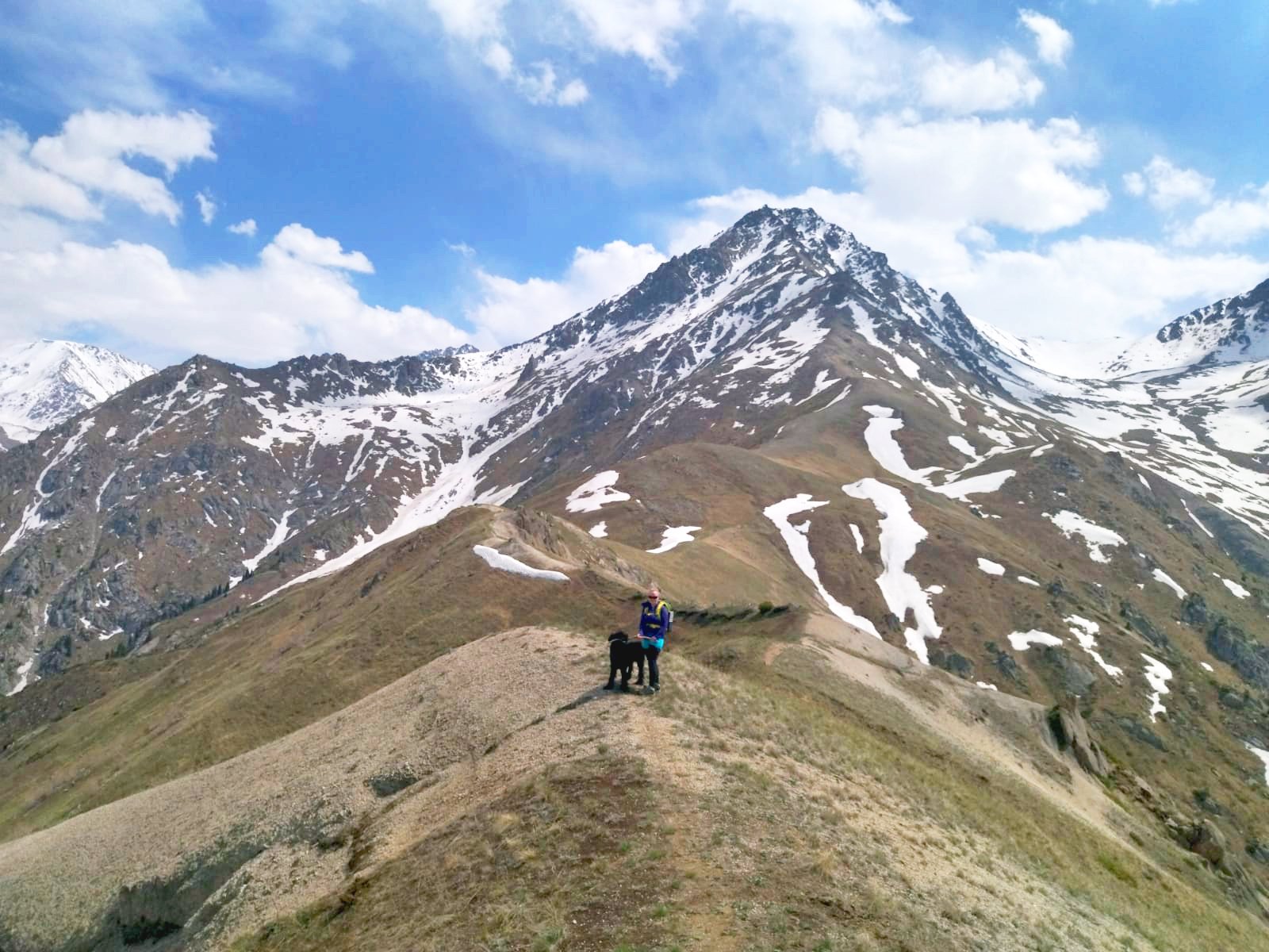
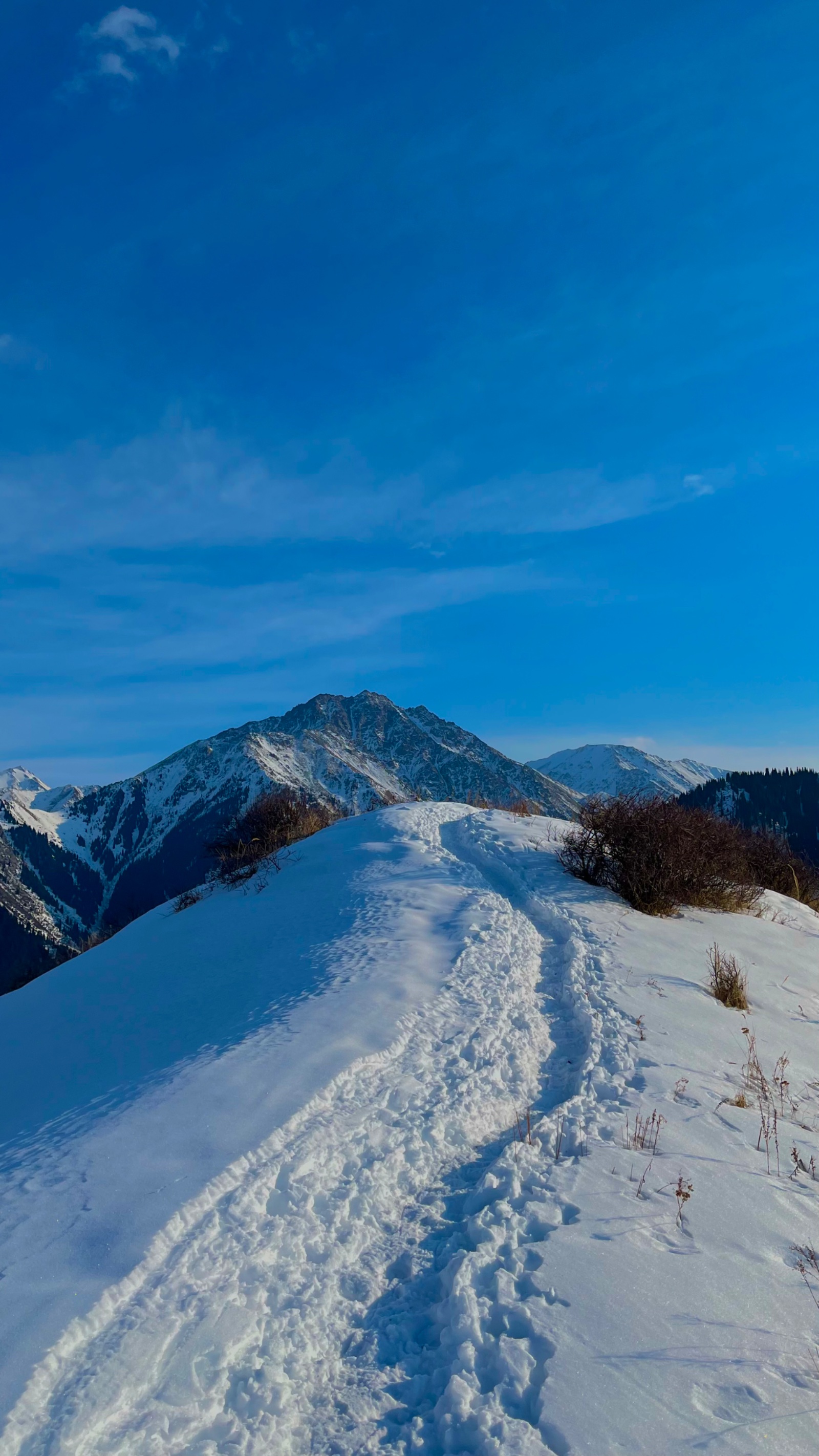
Ridge walk to Kaskabas summit (30–45 minutes)
From the pass, the route turns south along the ridge. This section is much easier — the ridge is broad, grassy, and the walking is pleasant. You’re above the treeline now, in the open, with views expanding with every step.
There is a lower summit at approximately 2,800 m that some hikers mistake for the true top. The actual highest point of Kaskabas (2,932 m) is about 1 km further south along the ridge. The true summit has a small plaque/marker.
The summit itself is bare rock and grass — the “bald head” that gives the mountain its name.
At the summit (30–60 minutes)
The summit panorama is extraordinary for a sub-3,000 m peak:
- South: Big Almaty Peak (3,682 m) — the iconic pyramid visible from Almaty — appears close and massive from this angle
- Southwest: Peaks Kamenskiy (3,627 m) and Kargalinskiy extend along the ridge — you can see the entire ridgeline stretching toward the Bliznets (Twins) pass
- West: The wide, green Kargalinskoye gorge stretches below, with the road to the Chapaevo settlement visible at its far end
- East: Prohodnoye gorge, with the route toward Terra meadow and Alyoshkin Bridge visible below
- North: Wolf Mountain (2,305 m) and beyond it, the skyline of Almaty city
- Northeast: The Big Almaty Gorge with the road winding toward Big Almaty Lake
The feeling of space is remarkable — you’re standing on a bald ridge with gorges falling away on both sides and the high peaks of the Zailiysky Alatau towering to the south.
Descent: Option A — Return via Kaskabas Pass (3–4 hours)
Retrace the ascent route. The steep grassy slope below the pass requires extra caution on descent — trekking poles are very helpful here. This is the shorter and more direct option.
Descent: Option B — Wolf Mountain loop (4–5 hours)
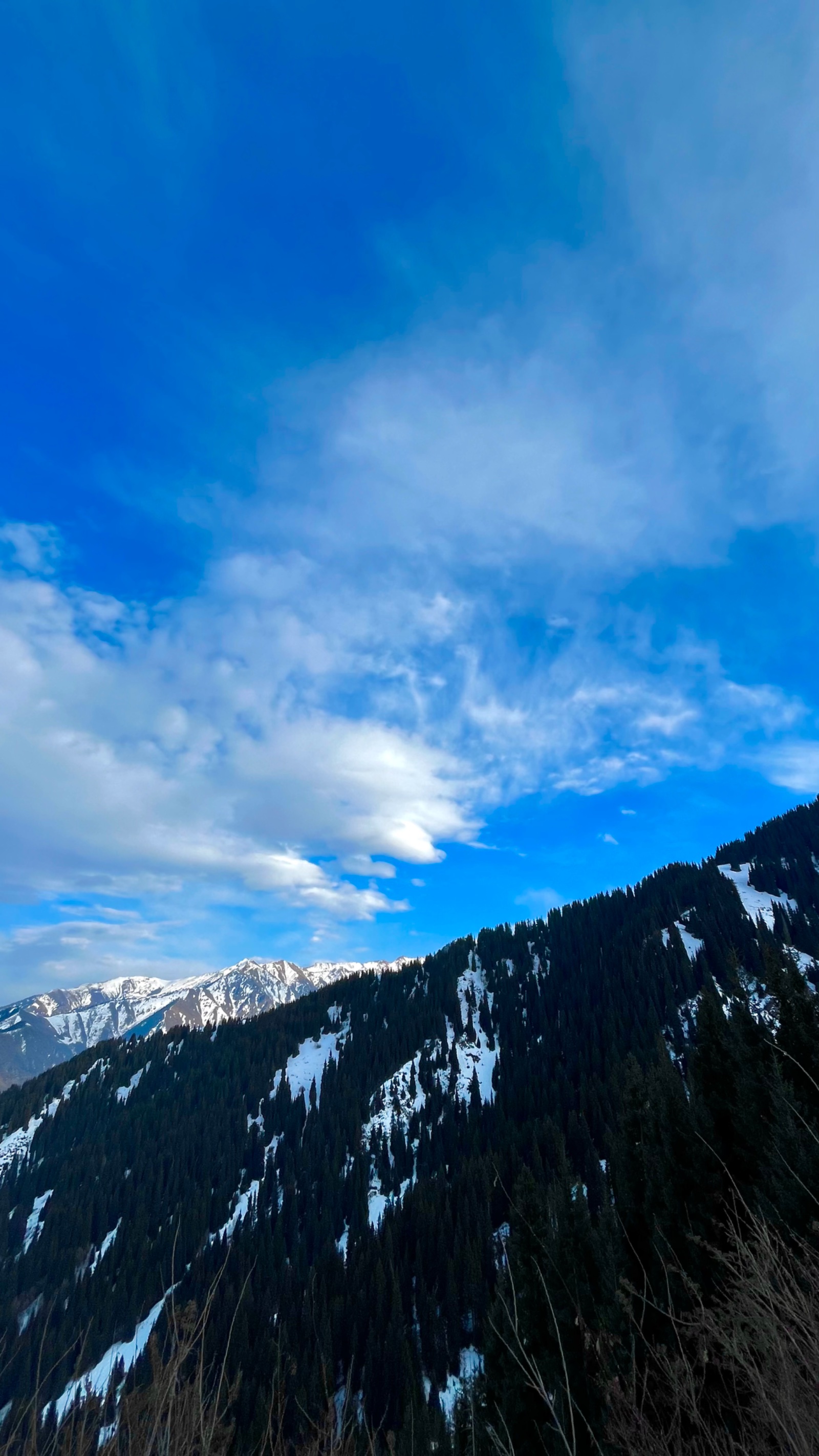
For fit hikers, a more interesting descent continues north from Kaskabas summit along the ridge, traversing to the Kokchaka Pass (2,170 m) and then to Wolf Mountain (Kokshoky, 2,305 m). Despite its name, wolves are rarely seen here today; the Kazakh name “Kokshoky” actually means “green hill.” Wolf Mountain’s summit is half-forested (spruce on the north side, open grass on the south) with panoramic views of four gorges simultaneously.
From Wolf Mountain, a good trail (the “Wolf’s Trail”) descends northeast through forest, eventually emerging near the Sunkar Falcon Nursery and the bus 28 ecopost stop. This loop adds distance but avoids re-descending the trailless Kaskabas slope, and the trail quality is much better.
This is the route listed as 2GIS Official Mountain Route #214.
Drive back to Almaty (30–40 minutes)
The “Bald Head” above four gorges
Kaskabas occupies a unique geographic position in the Zailiysky Alatau. Most Almaty hiking peaks — Furmanov, Panorama, Kumbel, even Big Almaty Peak — are located deep within single gorges, giving views along a valley axis. Kaskabas instead sits on the ridge that separates the Prohodnoye and Kargalinskoye drainage systems, which means you look into multiple gorges at once. Combined with the treeless summit, this creates a 360° panorama that’s hard to match at similar altitudes.
The Kargalinskoye gorge, visible from the summit, is one of the longest and least-visited gorges near Almaty. It’s historically important — a road through the gorge connects to the Chapaevo settlement — but it sees far fewer hikers than the Big Almaty or Small Almaty gorges. From Kaskabas, you’re looking at a landscape that most Almaty residents have never explored.
Why so few people climb Kaskabas?
Kaskabas is sometimes compared to Furmanov Peak in terms of accessibility and distance, yet it receives a fraction of Furmanov’s traffic. Several factors explain this:
The trailless section below the pass is genuinely difficult — there’s no formed path, the grass is tall and sometimes slippery, and the steepness is relentless. This is a significant barrier for casual hikers who expect maintained trails.
The summit is in the Big Almaty Gorge system, which is less accessible than the Small Almaty Gorge (Medeo/Shymbulak area). The bus 28 route is less frequent and less well-known to foreign tourists.
And unlike Furmanov or Kok-Zhailau, Kaskabas doesn’t appear on most English-language “top hikes in Almaty” lists. It’s a local’s mountain — and even among locals, it’s considered something of a hidden gem.
For guided tour clients, this is the appeal: you’re climbing a real mountain, to a real summit, and you won’t share it with anyone.
Why book a guided Kaskabas Peak hike?
This is not a hike to attempt independently unless you are experienced with route-finding in the mountains.
Navigation: The critical section between the spring and the pass has no visible trail. In fog or cloud, losing the route is easy and potentially dangerous. A guide who knows the exact line saves time and reduces risk.
Fitness assessment: The guide can assess your pace on the approach and make real-time decisions about whether to continue to the summit, stop at the pass (which still offers great views), or take a shorter alternative like Wolf Mountain instead.
Wolf Mountain loop logistics: The loop descent via Wolf Mountain requires knowing the correct ridge traverse and the turnoff to the Wolf’s Trail. A guide makes this loop feasible without the stress of self-navigation on an unfamiliar ridge.
Early start coordination: A 10–12 hour hike means departing Almaty very early. A guided tour with a driver eliminates the complexity of reaching the trailhead at dawn.
Safety: On a remote, minimally-trafficked route at nearly 3,000 m, having a guide with local knowledge and emergency plans is prudent.
FAQ: Kaskabas Peak Hike
How difficult is the Kaskabas hike? Rated 4/5 — this is one of the more demanding day hikes near Almaty. The total elevation gain is approximately 1,400 m over 18–22 km, with a sustained steep, trailless section on grass approaching the pass. It requires good cardiovascular fitness and hiking experience. It’s significantly harder than Furmanov Peak or Kok-Zhailau.
How long does the hike take? 10–12 hours total including breaks. Ascent to the summit takes 5–7 hours; descent 3–5 hours depending on route choice. Plan for a full dawn-to-dusk day.
Is there a trail the whole way? No. The first 3 km in the Kaskabas gorge follow a defined trail along the stream. But from the spring (~2,000 m) to the Kaskabas Pass (~2,600 m), the trail is almost nonexistent — you’re climbing a steep, grass-covered slope with minimal markings. The ridge above the pass is easier. This is the main reason a guide is recommended.
Where do I start? From the bus 28 terminus near GES-2 (2nd Hydroelectric Power Station) in the Big Almaty Gorge area, about 10 km south of central Almaty. The guided tour includes pickup from your accommodation.
When is the best season? June through October. The trailless slope is dangerous when snow-covered (late autumn through spring) and unpleasant when wet. July and August offer the best conditions and the longest daylight. In late July–August, you may find abundant wild mushrooms (ryzhiki / saffron milk caps) along the upper trail.
Can I do the loop via Wolf Mountain? Yes — this is actually the recommended descent route for strong hikers. From the summit, you traverse the ridge north to Kokchaka Pass (2,170 m), continue to Wolf Mountain (2,305 m), and descend via the Wolf’s Trail to the Sunkar falcon nursery and the bus 28 stop. This loop is listed as 2GIS Official Route #214. It avoids re-descending the trailless slope and offers additional views. It adds 1–2 hours compared to returning the same way.
How does Kaskabas compare to Furmanov Peak? Kaskabas is significantly harder. Furmanov (3,053 m) is higher but has a well-marked, popular trail with good infrastructure. Kaskabas has a trailless section, much less traffic, and a longer total route. The reward is solitude and a unique multi-gorge panorama that Furmanov can’t match.
Is water available on the route? Yes — the stream in the Kaskabas gorge provides water for the first 3 km, and the spring with a pipe at the trail fork (~2,000 m) is the last reliable water source. Fill up here. Bring at least 2.5–3 liters total.
Will I see anyone else on the trail? Probably not. Kaskabas is one of the least-trafficked routes near Almaty. Multiple trip reports note encountering zero other hikers for the entire day. This is both the appeal and the reason to go with a guide.
Can I see the Sunkar Falcon Nursery on the same day? If you take the Wolf Mountain loop descent, you’ll exit near the Sunkar Falcon Nursery (established 1989, home to 450+ birds of prey). However, after 10+ hours of hiking, most people just want to get home. Consider visiting Sunkar on a separate, easier day trip — the falconry show at 5 PM is the highlight.
What does “Kaskabas” mean? “Bald head” in Kazakh (kas = bald, bas = head). The summit is indeed bare — a treeless, grass-and-rock dome above the forest line.
Itinerary
Detailed itinerary will be provided upon booking. Our typical tour includes daily hikes through diverse terrains and cultural experiences.
Pricing
| Group Size | 1 person | 2 people | 3 people | 4 people | 5 people | 6 people Best value |
|---|---|---|---|---|---|---|
| Standard | $169 $169 total | $112 $224 total | $93 $279 total | $83 $332 total | $77 $385 total | $74 $444 total |
100% private tour — prices are per person based on group size. The more friends you bring, the less everyone pays!
What's Included
Included
Not Included
Our Guarantee
If weather forces a cancellation, you choose a free reschedule or a full refund. If you're not satisfied with your experience, we'll work with you to make it right. No questions, no hassle.
Private tours only (max 6) · Reschedule or full refund if weather cancels · No payment until confirmed
Traveler Stories
Sarah K.
Our guide was incredible - he adjusted the pace perfectly for our group and knew exactly where to stop for the best photos. The whole experience felt effortless, like everything was taken care of before we even thought to ask.
Marco T.
We were a group of 4 friends and the per-person price made it a no-brainer. Private 4x4, lunch included, and the canyon was breathtaking. Way better than the big bus tours we saw there.
Anna W.
Solo traveler here. I was nervous about hiking alone in a foreign country but the guide made me feel completely safe. The trail to Kok-Zhailau was beautiful and the photos he took of me were amazing. Only wish the hike was longer!
David R.
Third time booking with these guys. Butakovka, Big Almaty Lake, and now Titov Peak. Every single time the service is flawless. The fact that it's always private and max 6 people makes such a difference compared to other operators.
Share Your Experience


9+ hikers
completed this trail
Tour At A Glance
Book This Tour
Private tours run any day of the week — weekends fill up fastest, so book early
Pay securely after confirmation


Weather Forecast
overcast clouds
H: 20°C
L: 14°C
Tue, Jul 7
light rain
16°C
13° / 18°
Wed, Jul 8
light rain
16°C
13° / 19°
Thu, Jul 9
clear sky
16°C
12° / 20°
Tour Location
Similar trails
From $74
per person · weather refund
Complete Your Booking
Tour:
Date:
Participants
Add-ons
You're Almost There!
We'll contact you within 24 hours to confirm your spot and share everything you need to prepare for your adventure.
Request sent
We confirm your spot
within 24 hours
Summoning perfect weather
Hit the trail
On the channel
83 h
Drone flight hours
What we’ve filmed
59
Hikes filmed
704 km
Kilometers covered
44,439 m
Elevation gained
27
Countries visited
Plan your hike with us
A few quick questions and we will email you a tailored hike plan & quote.
When do you want to hike?
What's your experience?
How many of you?
Where do we send your plan?
Private guided hikes · no obligation.